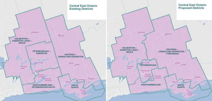
On Friday (August 19), the Federal Electoral Boundaries Commission for Ontario released a proposed electoral map for public consultation, which would see significant changes made to the federal ridings in the greater Kawarthas region to reflect population changes in the 2021 census.
Canada’s constitution requires that federal electoral districts be reviewed after each 10-year census to reflect changes and movements in Canada’s population.
“The proposal reflects Ontario’s increase in population from 12,851,821 in 2011 to 14,223,942, as captured in the 2021 Census, and takes into consideration communities of interest or identity, and historic and geographic factors,” read the Federal Redistribution website at redecoupage-redistribution-2022.ca, where you can also find maps and detailed descriptions of the proposed changes to ridings across Canada.
The population of Central East Ontario — which includes the existing ridings of Peterborough-Kawartha, Haliburton-Kawartha Lakes-Brock, Northumberland-Peterborough South, and Hastings-Lennox and Addington, as well as Bay of Quinte — grew by nine per cent, from 535,322 in 2011 to 583,287 in 2021, with an average population of 116,657 in 2021.
The commission shifted boundaries to balance the population of the electoral districts across Central East Ontario. The shift most significantly affects the existing riding of Hastings-Lennox and Addington, but also affects the existing ridings of Peterborough-Kawartha, Haliburton-Kawartha Lakes-Brock, and Northumberland-Peterborough South.
Under the proposed electoral map, Peterborough-Kawartha would be renamed Peterborough, Northumberland-Peterborough South would be renamed Northumberland, and Hastings-Lennox and Addington would be renamed Hastings-Lennox and Addington-Tyendingaga. Haliburton-Kawartha Lakes-Brock would retain its existing name.
The proposed Peterborough riding, comprising a population of 121,270 according to the 2021 census, would include the City of Peterborough, the portion of the Municipality of Trent Lakes comprising the islands of Curve Lake First Nation, the Townships of Douro-Dummer, Otonabee-South Monaghan, and Selwyn, part of Alnwick/Haldimand and part of Cavan Monaghan townships, and Alderville First Nation, Curve Lake First Nation, and Hiawatha First Nation.
The townships of Havelock-Belmont-Methuen and North Kawartha in Peterborough County would be moved into Hastings-Lennox and Addington-Tyendingaga, and the Municpality of Trent Lakes in Peterborough County (except for the islands of Curve Lake First Nation) would be moved into Haliburton-Kawartha Lakes-Brock.
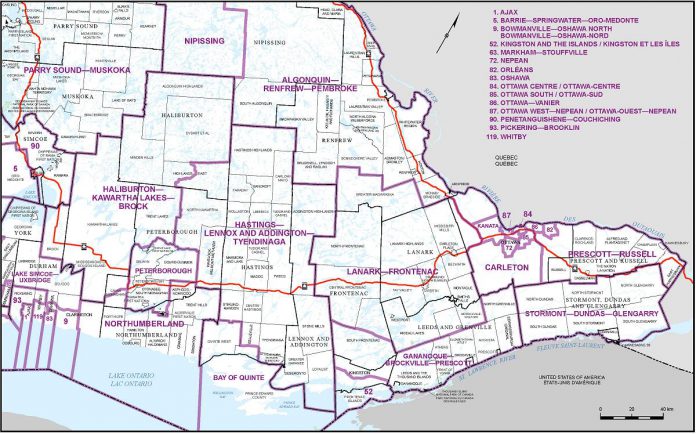
The proposed Haliburton-Kawartha Lakes-Brock riding, comprising a population of 120,241 according to the 2021 census, would include the City of Kawartha Lakes, the Municipality of Dysart et al, the western portion of the Municipality of Highlands East, the Municipality of Trent Lakes (except for the islands of the Curve Lake First Nation), the townships of Algonquin Highlands, Brock, and Minden Hills, and a portion of Cavan Monaghan Township.
The proposed Northumberland riding, comprising a population of 114,414 according to the 2021 census, would include the Town of Cobourg, the municipalities of Brighton, Port Hope, and Trent Hills, a portion of the Municipality of Clarington, the townships of Asphodel-Norwood, Cramahe, and Hamilton, and a portion of Alnwick/Haldimand and Cavan Monaghan townships. Otonabee-South Monaghan Township would move to the proposed Peterborough riding.
The proposed Hastings-Lennox and Addington-Tyendinaga riding, comprising a population of 111,331 according to the 2021 census, would include a portion of the City of Belleville, the towns of Bancroft, Deseronto, and Greater Napanee, the municipalities of Centre Hastings, Hastings Highlands, Marmora and Lake, and Tweed, a portion of the Municipality of Highlands East, the townships of Addington Highlands, Carlow/Mayo, Faraday, Havelock-Belmont-Methuen, Limerick, Loyalist, Madoc, North Kawartha, Stirling-Rawdon, Stone Mills, Tudor and Cashel, Tyendinaga, and Wollaston, and Tyendinaga Mohawk Territory.
The process for confirming the proposed electoral map is scheduled to continue until September 2023, when the final electoral districts will be determined.
“The new boundaries can only be put in place at a general election called at least seven months after the new electoral districts have been set,” reads the Federal Redistribution website. “This time allows for Elections Canada, political parties, candidates and sitting MPs to prepare for the next general election … We expect that the new federal electoral boundaries will take effect during a general election held after April 1, 2024, at the earliest.”
The commission is holding in-person and virtual public hearings this fall to gather comments and feedback on the proposed boundaries and electoral district names.
The first virtual hearing will take place on Monday, September 26th. If you want to make a representation at a hearing, you have to complete a public hearing participation form by September 26. A full list of virtual and in-person public hearings, along with the public hearing participation form, is available at redecoupage-redistribution-2022.ca, where you can also find instructions on how to make a submission in writing as an alternative to attending an in-person or virtual hearing.
PDF: Proposal of the Federal Electoral Boundaries Commission for the Province of Ontario
Proposal of the Federal Electoral Boundaries Commission for the Province of Ontario


