


")
Ontario is about to have a new federal electoral map, with significant changes to the electoral districts in the greater Kawarthas region.
On February 10, the Federal Electoral Boundary Commission for the Province of Ontario submitted its final 226-page report to the Chief Electoral Officer of Canada for consideration by the House of Commons. The new boundaries can only be put in place at a general election called at least seven months after the new electoral districts have been proclaimed, which will happen after Parliament has considered the report and the commission has addressed any objections.
Canada’s constitution requires that federal electoral districts be reviewed after each 10-year census to accommodate changes and movements in Canada’s population. The commission was tasked with redrawing 122 electoral districts in Ontario to reflect population changes in the 2021 census. The population within each electoral district was to match, as closely as possible, a “provincial electoral quota” of 116,590 (the total population in 2021 divided by the number of districts).
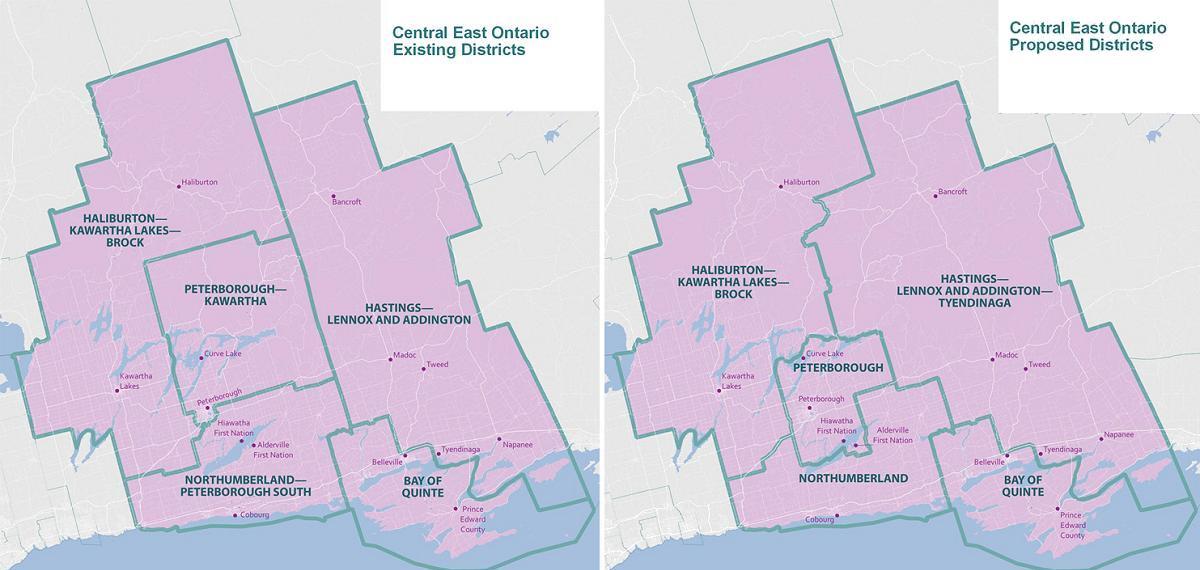
Last August, the commission released a proposed electoral map for public consultation. The final report incorporates the results of that consultation, with the final electoral map differing from the changes proposed last year — including for the four electoral districts in Central East Ontario: Peterborough-Kawartha, Haliburton-Kawartha Lakes-Brock, Northumberland-Peterborough South, and Hastings-Lennox and Addington.
In the commission’s final report, the four electoral districts will be renamed Peterborough, Haliburton-Kawartha Lakes, Northumberland-Clarke, and Hastings-Lennox and Addington-Tyendinaga. Below is a summary of the boundaries of each district and the changes from last year’s proposed electoral map as described in the final report.
The new Peterborough district consists of the City of Peterborough, Curve Lake First Nation and Hiawatha First Nation, the part of the Municipality of Trent Lakes comprising the islands of the Curve Lake Indian Reserve No. 35A, and the townships of Asphodel-Norwood, Douro-Dummer, Havelock-Belmont-Methuen, Otonabee-South Monaghan, and Selwyn.
The new Haliburton-Kawartha Lakes district consists of the City of Kawartha Lakes, the municipalities of Dysart et al and Highlands East, the Municipality of Trent Lakes (except the islands of the Curve Lake Indian Reserve No. 35A), and the townships of Algonquin Highlands, Cavan Monaghan, North Kawartha, and Minden Hills.
The new Northumberland-Clarke district consists of the Town of Cobourg, the municipalities of Brighton, Port Hope, and Trent Hills, the townships of Alnwick/Haldimand, Cramahe, and Hamilton,
Alderville First Nation, and a portion of the Municipality of Clarington.
The new Hastings-Lennox and Addington-Tyendinaga district consists of that part of the City of Belleville north of Highway 401, a portion of the City of Quinte West, the towns of Bancroft, Deseronto, and Greater Napanee, the municipalities of Centre Hastings, Hastings Highlands, Marmora and Lake, and Tweed, the townships of Addington Highlands, Carlow/Mayo, Faraday, Limerick, Loyalist, Madoc, Stirling-Rawdon, Stone Mills, Tudor and Cashel, Tyendinaga, and Wollaston, and the Tyendinaga Mohawk Territory Indian Reserve.
Last year, the commission had proposed shifting the boundaries of the existing district of Peterborough-Kawartha southward based on submissions received during the initial consultation phases that stressed the established connection of the Township of Otonabee-South Monaghan with Peterborough. Since Alderville First Nation has territory on both sides of Rice Lake, the boundary was shifted further south to ensure all of Alderville First Nation’s territory would be in the same district. The name Peterborough was proposed during initial consultations and will be maintained as the final district name, but its boundaries have been altered from the initial proposal.
The commission heard over the course of public hearings that the southward shift was inappropriate, because the small portion of the proposed Peterborough district south of Rice Lake (comprising the hamlet of Roseneath and the main reserve of Alderville First Nation) were more appropriately aligned with the district of Northumberland. This suggestion, which was initiated by the Township of Alnwick/Haldimand and Alderville First Nation and supported by several other municipalities within Northumberland County, has been implemented by the commission.
There was support for dividing Clarington as proposed, by maintaining Clarke as part of the Northumberland district, although others suggested that Clarington, which resulted from the merger of Clarke and Darlington, should not be divided. With Clarke remaining in the Northumberland district, the commission accepted a suggestion that the name of the district should include a reference to “Clarke”; hence, the name for the district will be Northumberland-Clarke.
For the other proposed changes impacting the Peterborough area, the commission received some support for creating a more compact urban riding, while others expressed the desire for the existing boundaries to remain the same. Residents from five municipalities within Peterborough County, with support from municipal officials, indicated a desire to be aligned with the City of Peterborough and ultimately be part of the Peterborough district. These are the Municipality of Trent Lakes, the Township of Havelock-Belmont-Methuen, the Township of Asphodel-Norwood, the Township of Otonabee-South Monaghan, and the Township of North Kawartha.
The commission was able to implement the request of two townships and the alternative request of a third township. Ultimately, the commission concluded that the Township of Havelock-Belmont-Methuen, the Township of Asphodel-Norwood, and the Township of Otonabee-South Monaghan be included within the Peterborough district. However, the commission was unable to keep Trent Lakes and North Kawartha in Peterborough as the population of the district was already more than 10 per cent higher than the desired provincial electoral quota of 116,590.
Instead, the Township of North Kawartha and the Municipality of Trent Lakes are being moved into Haliburton-Kawartha Lakes. The commission decided North Kawartha and Trent Lakes should go into Haliburton-Kawartha Lakes together, as this would create three Peterborough County municipalities within this district.
The commission had originally proposed the Township of Cavan Monaghan be divided between Peterborough, Haliburton-Kawartha Lakes-Brock, and Northumberland. Instead, Cavan Monaghan will remain entirely within the district of Haliburton-Kawartha Lakes as requested by the township and residents. The commission acknowledged the earlier proposed boundaries would have been problematic given that the township was split into three districts.
The commission also heard concerns that proposed redistribution arbitrarily divided the Municipality of Highlands East between districts. This municipality noted the value of maintaining political cohesion with Haliburton County with respect to federal policies affecting its region. The commission implemented the suggestion, supported by other municipalities, to maintain the whole of the Municipality of Highlands East in the district of Haliburton-Kawartha Lakes.
The Township of Brock has been moved from Haliburton-Kawartha Lakes to York-Durham, aligning it with several other municipalities within the Regional Municipality of Durham. As a result, the new district name will be Haliburton-Kawartha Lakes.
These changes also resulted in a cascading effect on the Hastings-Lennox and Addington-Tyendinaga and Bay of Quinte districts.
The boundary between these districts was redrawn to divide the City of Quinte West on Highway 401 and the Trent River, in a similar manner to how Belleville has been historically divided, and to place rural portions of Quinte West in the riding of Hastings-Lennox and Addington-Tyendinaga. Care has been taken to not divide the community of Frankford.
The names, 2021 populations, and deviations from the 2022 provincial electoral quota of 116,590 for Central East Ontario’s final districts are Peterborough (128,349, +10.09%), Haliburton-Kawartha Lakes (119,150, +2.20%), Northumberland-Clarke (106,574, -8.59%), Hastings-Lennox and Addington-Tyendinaga (106,468, -8.68%), and Bay of Quinte (110,164, -5.51%).
PDF: Report of the Federal Electoral Boundaries Commission for the Province of Ontario
Report of the Federal Electoral Boundaries Commission for the Province of Ontario


