


")
Do you love those before and after pictures of renovated kitchens and bathrooms?
What if I told you I have some before and after photos and videos of re-imagined public spaces in Peterborough?
Since 2017, GreenUP’s NeighbourPLAN program has supported residents to re-imagine public spaces in three neighbourhoods in Peterborough: Talwood, Downtown Jackson Creek, and Jackson Park-Brookdale.
NeighbourPLAN uses a co-design process that helps prioritize the issues that matter most to residents. As a resident, you know your neighbourhood in ways no one else can. You are an expert.
Through this co-design process, residents worked with built environment professionals to create inspiring vision documents. These vision documents can be used by neighbours and community partners to move their ideas forward.
In these vision documents, you can see before and after comparisons of how neighbourhoods look now and illustrations of what neighbourhoods could look like. Visit our website at greenup.on.ca/neighbourplan to explore the vision documents.
A vision document is not the same as actually experiencing these changes in real life. With that in mind, we brought some of these ideas to life just for one afternoon in October with temporary infrastructure pop-ups. You can watch a video showing the before/after transformation of these popups below and if you follow @PtboGreenUP on social media.
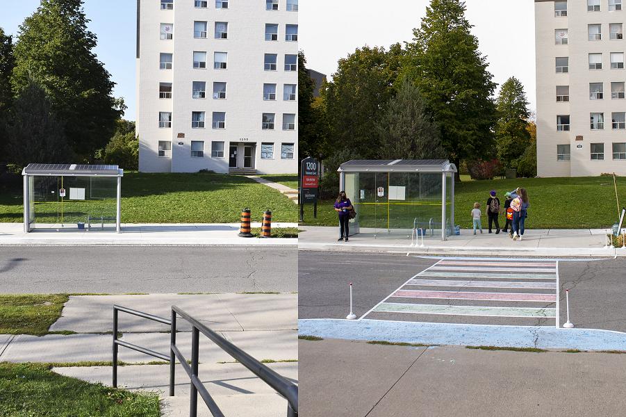
Talwood Drive is the heart of one of the highest density areas of Peterborough. Residents are concerned about high-speed traffic in dense residential areas and a lack of pedestrian crossings.
Reducing traffic speed in residential areas saves lives. A study of road safety by the World Health Organization confirms a clear relationship between speed and injury severity. This is particularly true for the most vulnerable road users, such as pedestrians and cyclists.
For example, when a pedestrian is hit by a car travelling at 30 km/h or slower, they have a 90 per cent chance of survival. However, that chance of survival reduces to 50 per cent when the car is travelling at 45 km/h.
For our infrastructure pop-up, we added a pedestrian crossing next to a transit stop and convenience store in the heart of Talwood. We included small bump outs (projections) of the curb on either side of the crosswalk. These bump outs slow vehicle traffic and shorten pedestrian crossing distances.
We also added colour to the crossing, which can signal to drivers that they should expect pedestrian activity. The colour can also contribute to neighbourhood vibrancy and place-making.
Adding benches, lighting, and planters would also enhance this public space and create a welcoming, safe, and accessible focal point in the Talwood neighbourhood.
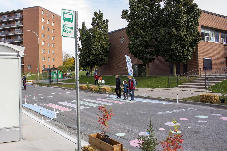
In the north end of Peterborough, we did an infrastructure pop-up at the intersection of Chesterfield and Downie, south of Brookdale Plaza. Like many streets in Peterborough, Chesterfield and Downie meet at an irregular angle.
This can create an unusually large intersection, which makes for long pedestrian crossings. The large intersection also means vehicle speed tends to be higher and the path vehicles take around corners is less predictable.
To address these concerns, we tightened the intersection by extending the curbs on all sides. These curb extensions significantly shorten pedestrian crossings —, in this case, by about half the previous distance. The curb extensions also realign the intersection so that vehicles move more predictably.
A smaller curb radius creates a tighter corner for vehicles. This means vehicles have to take the turn more slowly, thereby improving pedestrian safety.
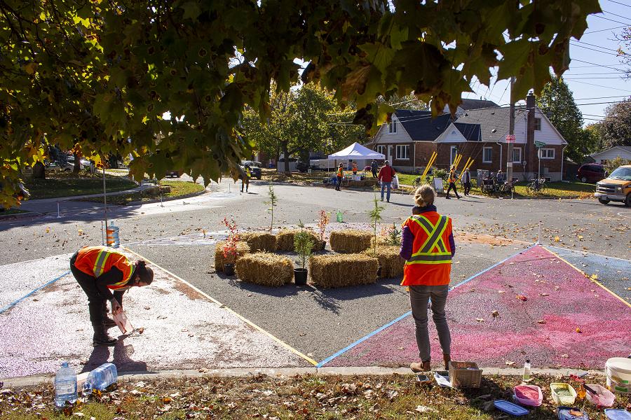
It was great fun to spend a beautiful autumn afternoon in these neighbourhoods, demonstrating some of the ideas shared in the vision documents. All users benefit when we enhance roads with infrastructure that prioritizes safety for walkers and rollers.
These enhancements do not need to be expensive rebuilds. Paint, bollards, and planters can offer quick solutions to public space challenges.
These temporary infrastructure pop-ups are part of a growing global movement. Citizens, organizations, and municipalities are using this temporary, cost-efficient approach to demonstrate and test long-term changes. People sometimes call this “tactical urbanism”.
For our temporary infrastructure pop-ups, we used potted plants, straw bales, tape, chalk, and other items to demonstrate potential changes for one afternoon. Municipalities can use relatively low-cost but more substantial materials like bollards, paint, planters, and benches to test an idea over a longer period of time.

We’d love to see local municipalities and residents embrace creative solutions like this, to test ideas and explore ways to celebrate public spaces. Would you?
Are you interested in learning more about how infrastructure changes can make safer roads and neighbourhoods?
Check out the “Visit a Street” section of the Pedestrians First Toolkit by the International Institute for Transportation and Development Policy at pedestriansfirst.itdp.org/street. For great explanations and visuals, explore the National Association of Transportation Officials’ Urban Street Design Guide at nacto.org/publication/urban-street-design-guide/.
VIDEO: GreenUP NeighbourPLAN Infrastructure Pop-up Projects


